Kayaking and Stand-up Paddleboarding
on Lakes around Donner Summit
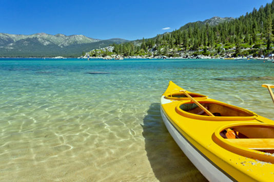
Ever increasing in popularity, flat-water kayaking and stand-up paddleboarding (SUP) are enjoyed at a wonderful variety of lakes spread over a wide area around Donner Summit. Popular destinations range from low elevation lakes such as Rollins Lake and Scotts Flat Lake to high mountain waters such as Donner Lake, Jackson Meadows, and Spaulding.
Adventurous paddlers, seeking quieter waters, explore more remote spots like Feeley Lake and Blue Lake.
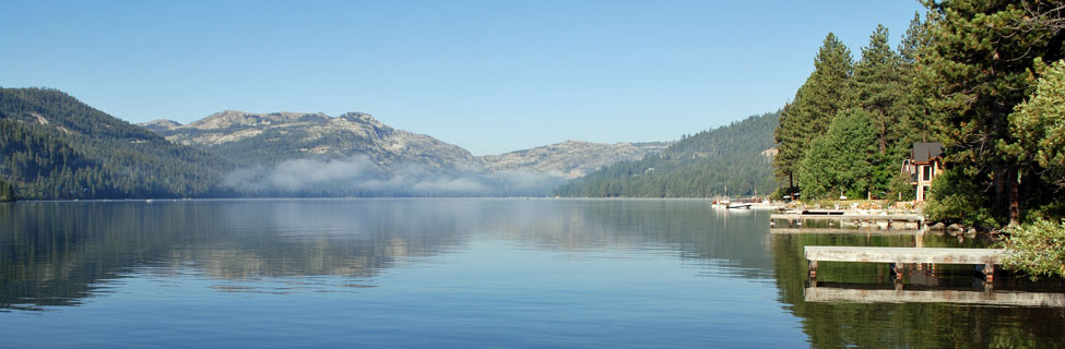
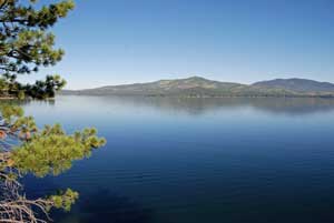
Donner Lake Kayaking and SUP
Location: Next to Interstate 80 near Truckee
Elevation: 5,900 feet Surface Acres: 960 Shoreline: 7½ miles
Types of Boating: All kinds - canoes, kayaks, SUP, waterskiing, jet skiing
Donner Lake is one of the most beautiful lakes in the Sierra, making it an ideal place for paddlers. The lake has a 35 MPH speed limit during the day; 10 MPH between sunset and sunrise. As at most area lakes, paddle sports are best in the morning. Afternoon winds can generate serious chop. Along the north shore are over 30 public docks for boaters and swimmers.
Public Launch Ramp: Northwest end of lake
Donner Lake Watersports and Marina
Donner Lake Marina
15695 Donner Pass Rd., Truckee CA
(530) 582-5112 Donner Lake Watersports
Located at the west end of the lake just west of the launch ramp.
Marina with docks, slips, boat rentals, fuel available nearby
Donner Lake Marina
East shore at Donner Memorial State Park.
(530) 582-5112 Donner Lake Marina
| Boat | Length | Seats |
|---|---|---|
| Half Day = 4 hours, full day = 8 hours. Prices subject to change. Wet Suits available. | ||
| Kayaks | 1-2 | |
| Canoes | 4 | |
| Stand-up Paddleboards | 12' | |
Shop Amazon:
Kayaking Best Sellers
Kayaking Best Sellers
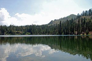
Lake Spaulding
Location: 25 miles east of Nevada City, off Highway 20
Elevation: 5,000 feet
Surface Acres: 698
Shoreline: 9 miles
Types of Boating: all types, including kayaking, SUP, jet skis and waterskiing
Lake Spaulding is surrounded by high granite peaks and thick conifer forests. Its 9 miles of shoreline offer dozens of wonderful inlets to explore. The lake has a 35 MPH speed limit during the day and 10 MPH at night. Access to the shoreline is best from the campground and day-use area operated by PG&E.
Launch Ramp west end of lake near the dam, $7 for day-use parking only, $10 launch and park fee, $50 annual pass, usually open mid-May to mid-October.
Scotts Flat Lake
Location: 4 miles Off Highway 20 on Scotts Flat Road
Elevation: 3,100 feet
Surface Acres: 850
Shoreline: 7½ miles
Types of Boating: Canoes, kayaks waterskiing, sailing, but no jet skis
There are two launch ramps and a marina. Scotts Flat Lake is popular for boating, swimming, fishing, and camping.
Scotts Flat Lake Campground 23333 Scotts Flat Road, Nevada City, CA
Reservations (530) 265-5302, Administration (530) 265-8861, Marina (530) 265-0413
Scotts Flat Lake Campground
Concrete launch ramp, gas and oil, mooring, storage space
Fees: Days Use for vehicle with up to 4 persons $15, boat launch $20
Boat rentals are handled through Mountain Recreation. Rentals can be arranged at their Grass Valley store or, beginning on Memorial Day weekend, at a kiosk at Scotts Flat Lake Day-Use Area, 10:30 AM to 6:00 PM.
| Boat | Features |
|---|---|
| Single Kayak/SUP | includes life jacket and paddle |
| Tandem Kayak or Canoe | includes paddles and life jackets |
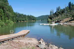
Rollins Lake
Location: 3 miles north of Colfax, off Highway 174
Elevation: 2,100 feet
Surface Acres: 900
Shoreline: 25 miles
Types of Boating: all types, including kayaks, canoes, SUP, jet skis and waterskiing.
Rollins Lake is a Nevada Irrigation District reservoir along the Bear River. The popular lake has 4 campgrounds and marinas around its shores. Miles of winding shoreline provide plenty of inlets to explore along with several sheltered arms with no-wake zones. The lake speed limit is 50 MPH during the day and 10 MPH from sunset to sunrise. Paddlers often find few other boats on the lake in the early morning, especially mid-week.
Rollins Lake Boat Rentals at Long Ravine
Sierra Pontoon Rentals is located at Long Ravine, 26909 Rollins Lake Rd., off Highway 174. There is an $15 day-use fee (or $18 with canoe or kayak) at Long Ravine Campground. After 4 PM, Monday-Thursday, rates are $8 per vehicle, $11 with canoe or kayak. Rollins Lake Boat Rentals are open 6 days a week from 10:00 am to 6:00 PM. Call for boat reservations: (916) 223-8129.
Personal Watercraft Rentals
- Kayaks, single or double
- Stand-Up Paddleboards
- Canoes (fishing allowed)
Peninsula Campground
Peninsula Campground is located off You Bet Road on the north side of the lake. There is an $15 day-use fee (or $18 with canoe or kayak). After 4 PM, Monday-Thursday, rates are $8 per vehicle, $11 with canoe or kayak.
(530) 477-9413
| Boat | Seats |
|---|---|
| Tandem Kayak | 2 (350 lbs. max) |
| Canoe | 3 (570 lbs. max) |
Orchard Springs Resort
Orchard Springs Resort is located on the west shore of Rollins Lake, off Highway 174 via Orchard Springs Road. They are open year-round. The resort has campsites, cabins, a beach, a marina, and store. Day-use fees are $15 per vehicle, $18 with up to 2 kayaks, canoes, or paddleboards. (530) 346-0073
Greenhorn Campground
Greenhorn Campground is located on the northwest side of the lake. To reach the campground take Greenhorn Access Road off Highway 174 and follow the road to the campground. They have a marina, launch ramp, boat rentals, store, arcade, campgrounds, and beach. Call for current entrance and boat launch fees. (530) 272-6100
Bowman Lake Road Lakes
Fuller Lake
Location: 3.5 miles north of Highway 20 on Bowman Lake Road.
Elevation: 5,343 feet
Length: ½-mile
Shoreline: 1.3 miles
Types of Boating: Kayaks, canoes, rafts, fishing boats
Fuller Lake has a 10 MPH speed limit, making it popular with anglers who like to use float tubes and with kayakers. Access is free at the parking area near the dam. The day use area and launch ramp farther up the shore charge $7 for day use and $3 more for launching a boat there.
Rucker Lake
Location: 5 miles north of Highway 20 on Bowman Lake Road, turn at dirt road (Rucker Lake Rd.) to the lake.
Elevation: 5,462 feet Length: ¾-mile Shoreline: 1.75 miles
Types of Boating: Non-motorized boats only, hand launched.
Rucker Lake is operated by PG&E. There is a primitive campground there.
Blue Lake
Location: 5 miles north of Highway 20 on Bowman Lake Road, turn at dirt road to Rucker Lake. Beyond Rucker Lake the road continues as a rugged, high-clearance-vehicle jeep trail for 1 mile.
Elevation: 5,941 feet Length: ½-mile Shoreline: 1.5 miles
Types of Boating: Non-motorized boats only, hand launched.
Blue Lake is a pristine mountain lake, a wonderful destination for kayakers and stand-up paddleboarders. There are no facilities, but the scenery is magnificent.
Carr Lake
Location: 8.5 miles north of Highway 20 on Bowman Lake Road, turn onto dirt road and go 3 miles to lake. High clearance vehicles needed.
Elevation: 5,941 feet Length: ¼-mile Shoreline: 0.75 miles
Types of Boating: Hand launched fishing boats, kayaks, canoes. 10 MPH speed limit.
Carr Lake has an adjacent campground. The lake itself is not particularly attractive, but other lakes are nearby.
Feeley Lake
Location: 8.5 miles north of Highway 20 on Bowman Lake Road, turn onto dirt road for Carr Lake and go 3 miles to lake. High clearance vehicles needed. Hike 1/3 mile on dirt road to Feeley Lake.
Elevation: 6,724 feet
Length: 0.75 miles
Shoreline: 1.3 miles
Types of Boating: Hand-launched light fishing boats, kayaks, canoes
Ambitious boaters could carry a lightweight craft the one-third mile to Feeley Lake along a fairly manageable dirt road. 10 MPH speed limit.
Lower Lindsey Lake
Location: 8.5 miles north of Highway 20 on Bowman Lake Road, turn onto Carr-Lindsey Lakes dirt road. After 2 miles turn left onto Lindsey Lake Road. Continue 2 miles to lake. High clearance vehicles needed.
Elevation: 6,236 feet
Length: 1/3-mile
Shoreline: 1 mile
Types of Boating: Fishing boats, kayaks, canoes. 10 MPH speed limit. Informal launch area.
Lakes North of Truckee
Stampede Reservoir
Location: 15 miles northeast of Truckee.
Elevation: 5,850 feet
Surface acres: 3,340
Shoreline: 25 miles
Types of Boating: Open to all kinds of boating, including waterskiing, jet skis, kayaking, canoeing, and sailing
Stampede Reservoir is best known for fishing, camping, and waterskiing. Facilities at the lake include two campgrounds and 3 boat launch ramps (2 within the campgrounds). Captain Robert's Boat Ramp charges $4 for day-use. There is a 45 MPH speed limit from sunrise to sunset and 10 MPH from sunset to sunrise. Quagga and zebra mussel boat inspections recommended before launching.
Independence Lake
Location: 20 miles north of Truckee via Highway 89 and Independence Lake Road
Elevation: 6,944 feet Length: 2.4 miles Shoreline: 6 miles
Types of Boating: Only boats provided by the Nature Preserve at Independence Lake - aluminum boats and kayaks, provided free on a first-come, first served basis.
Independence Lakes is jointly managed by the Truckee Donner Land Trust and The Nature Conservancy. Watercraft are available for use on Independence Lake Preserve from Memorial Day weekend through October.
Before visiting the lake, read more about it at Nature Conservancy.
Jackson Meadows Reservoir
Location: 32 miles northwest of Truckee via Highway 89 and Jackson Lake Road.
Elevation: 6,036 feet
Surface acres: 960
Shoreline: 11.2 miles
Types of Boating: All kinds of
boating are permitted on the lake.
Jackson Meadows Reservoir is a beautiful mountain lake with two launch ramps, one on the east side at Pass Creek Campground and
the other on the west side at Woodcamp. A number of great campgrounds are situated around the lake.
Other Donner Summit Area Lakes
Lake Valley Reservoir
Location: 2½ miles south of Interstate 80 at Yuba Gap
Elevation: 5,786 feet
Surface acres: 300
Shoreline: 5.2 miles
Types of Boating: Kayaks, canoes, sailboats, wind surfing, fishing boats. Water skiing is not allowed.
Lake Valley Reservoir is not as well-known as some of the other lakes in the area. Kayakers enjoy exploring the shoreline. There is a campground near the dam.
Silvertip Day Use and Launch Ramp: Located on the north side of the lake. $10 launch and park fee. $5 for day-use only. Usually open from mid-May through mid-November.
Sterling Lake
Location: 5 miles north of Cisco Grove on Rattlesnake Road
Types of Boating: Fishing boats, kayaks, canoes
The road to Sterling Lake is steep and winding in
places. Sterling Lake has a 10 MPH speed limit. There is no launch ramp.
Fordyce Lake
Fordyce Lake is only accessible by 4-wheel vehicle over rugged OHV roads. Most 4-wheelers approach via Eagle Lakes or Meadow Lake. Only non-motorized boats are allowed on the lake. Canoeists and kayakers enjoy exploring its nearly 4-mile length.
French Meadows Reservoir
3-mile long French Meadows Reservoir is 36 miles east of Foresthill, which is 17 miles from Interstate 80 at Auburn. All kinds of boating are permitted at the lake, but submerged hazards make it risky for water-skiers and high-speed boating. There are two paved launch ramps and several campgrounds.
Meadow Lake
Meadow Lake is located 35 miles from Truckee via Highway 89, Jackson Lake Road, and Meadow Lake Road. The last several miles require high clearance vehicles. Trailers are not advised. Boating is limited to hand-launched boats.