Mountain Biking around Donner Summit
There are too many good trails around Donner Summit to begin to list them all. Some of the best are shown here, with maps for most of them. Especially popular is the 25-mile Pioneer Trail shown at the bottom of this page.
Other popular areas included here are the roads and trails around Boca Reservoir, Donner Lake, Grouse Ridge, and many more. For even more suggestions for good mountain bike riding, have a look at our OHV section.
A number of great bicycle shops in the area serve as a resource for mountain bikers, including Tour of Nevada City Bicycle Shop, a long-time favorite of cyclists in the area.
Shop Amazon:
Mountain Biking Accessories
Joshua M. Hardt Memorial Trail at Sugar Pine
Distance: 3.5-mile loop
Elevation changes: 100 feet (3,600' - 3,700')
Starting Point: Sugar Pine Boat Ramp or Manzanita Day Use Area at Sugar Pine Reservoir, 30 miles from Auburn via Foresthill Road and Sugar Pine Road. ($3 day use fee to park)
This easy route circles Sugar Pine Reservoir. The trail winds along the shore with plenty of spots to stop for a break. A bridge spans Forbes Creek. Picnic tables, BBQs, and restrooms are available at the day use area.
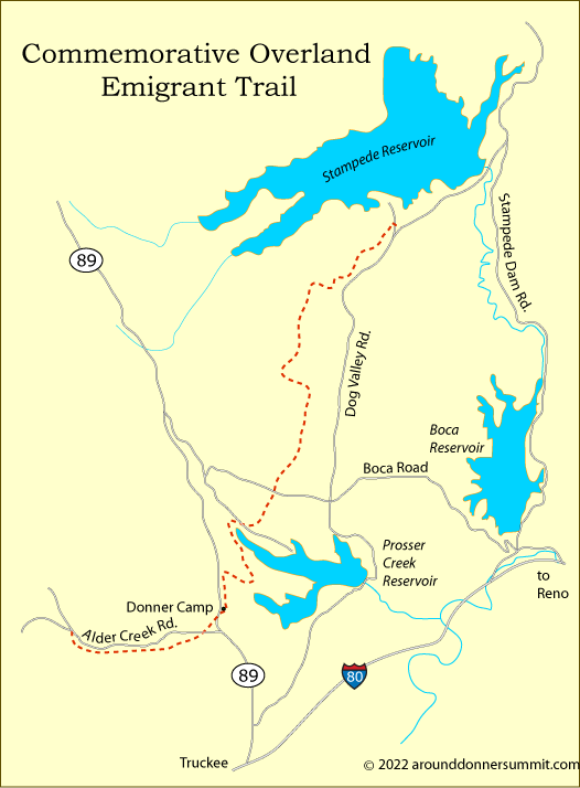
Commemorative Overland Emigrant Trail
Distance: 13 miles one way
Elevation: +1,000 feet and -1,000 feet (6,200' - 5,750' - 6,100' - 5,800' - 6,000')
Starting Point: Alder Creek Road west of Prosser Creek Reservoir or Dog Valley Road at Stampede Reservoir
Starting at Alder Creek Road the trail heads downhill, paralleling the road for 2½ miles before crossing and angling northeast to the Donner Camp. A picnic area with restrooms and water are found there. Then the trail circles the northwest end of Prosser Creek Reservoir before aiming north toward Stampede Reservoir, ending on Dog Valley Road.
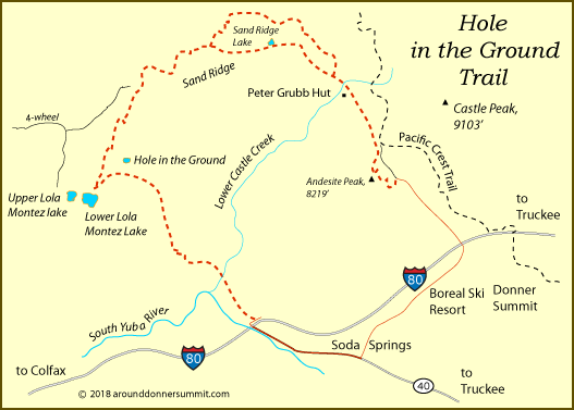
Hole in the Ground
Distance: 12 miles one way, 15-mile loop
Elevation changes: +1,600 feet, -2,100 feet (7,200' - 8,000' - 6,600')
Starting Point: Castle Valley opposite side of I80 from Boreal Ski Area at Donner Summit
Start up the side of Andesite Peak, climbing to 8,000 feet and then drop slightly crossing Lower Castle Creek. Then climb again at Sand Ridge to 8,000 feet at mile 5. Beyond mile 5 the trail descends almost continuously, passing near Hole in the Ground. Take the short side-trip to Lower Lola Montez Lake, a good stopping place. Then continue on down to Interstate 80. By crossing the overpass to Soda Springs, you can take a 3-mile road back to your starting place.
In places the route passes through private property, and naturally you will want to stick to the trail. Also. it's good to remember that bikes are not allowed on the Pacific Crest Trail.
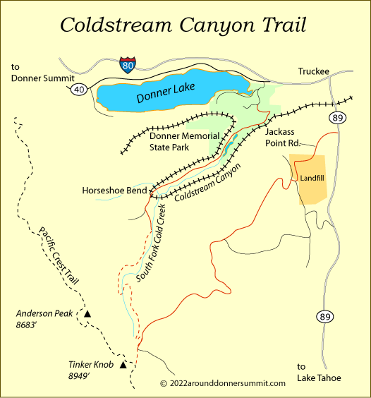
Coldstream Canyon
Distance: 8 miles one way from Donner Memorial State Park, 9 miles one way from Highway 89, or 19-mile loop
Elevation changes: Total climb +2,400 feet (range 5,800' - 8,200')
Starting Point: Donner Memorial State Park, Truckee, or Highway 89 at Jackass Point Road
The Coldstream Canyon trail route begins at or near Donner Memorial State Park. Ride out Coldstream Canyon past Horseshoe Bend (mile 3) and pick up a 4-wheel road that climbs along the South Fork of Cold Creek. The road soon becomes a steep single-track leading up to the crest of the Sierra at Tinker Knob. Near the summit you join a 4-wheel road for a short distance and return to trail for the final push. Once on top, note that bicycles are not allowed on the Pacific Crest Trail. It's an easy foot scramble to the top of Tinker's Knob, but use caution.
To turn your ride into a loop route, on your return stay with the 4-wheel road you found near the summit, following it to the northeast down the mountain. The grade via this route is not quite as steep as Coldstream Canyon. Eventually you join Jackass Point Road which passes above the landfill and then drops down to Highway 89 (9 miles). Complete the loop by riding north to Truckee and out to Donner Memorial State Park.
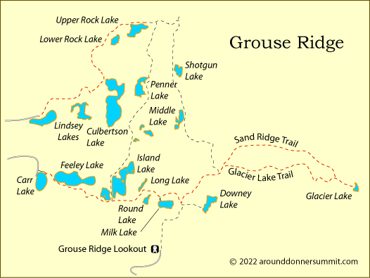
Grouse Ridge - Carr Lake to Glacier Lake
Distance: 5.5 miles one way
Elevation changes: Total climb +850 feet (range 6,700' - 7,550')
Starting Point: Carr Lake
From the parking lot at Carr Lake ride east past Feeley Lake and then climb a moderate grade past Island Lake and Milk Lake. At mile 3 you can choose the lower trail to the right leading to Glacier Lake or the Sand Ridge trail, which also leads to Glacier Lake (not shown on all maps). The ridge trail is more exposed, smoother, and offers views of the Grouse Ridge area. Many alternate routes and trails are available. Using both Forest Service maps and USGS maps will give you a better account of all the available trails.
Grouse Ridge - Lindsey Lakes to Upper Rock Lake
Distance: 3 miles one way
Elevation changes: Total climb +500 feet (range 6,250' - 6,750')
Starting Point: Lindsey Lakes
From Lindsey Lakes ride up the Rock Creek Lake trail, climbing gradually in the first mile to a ridge overlooking Culbertson Lake. Then descend to Texas Creek and begin a steady climb to Upper Rock Lake. Trails from there connect with the Carr Lake area.
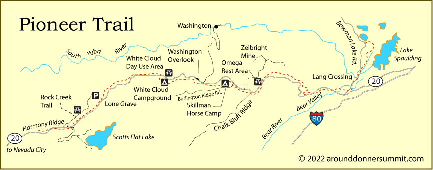
Pioneer Trail
Distance: 25 miles one way
Elevation changes: +2,000 feet (3,500' - 5,500')
Starting Points: Along Highway 20 east of Nevada City: Harmony Ridge Market, Lone Grave, White Cloud Picnic Area, Washington Overlook trailhead,
Upper Burlington Trailhead, Chalk Bluff trailhead, Omega Rest Stop, Ziebright Mine, and on Bowman Lake Road access at Lang crossing. (see map)
This easy to difficult trail parallels Highway 20, climbing and descending. At Bowman Lake Road the trail follows the road to the South Yuba River at Lang Crossing. From there it climbs nearly solid rock, then moves into oak woodlands before entering mixed conifers and joining the Spaulding Lake trail at a penstock (pipe). There the bike route turns left and travels a quarter mile back to Bowman Lake Road.