Donner Summit Boating
Boaters have a wide range of lakes and reservoirs from which to choose on either side of Donner Summit. Many lakes such as Spaulding, Donner Lake, and Boca are easily accessible from Interstate 80. Others like Meadow Lake and French Meadows Reservoir require miles of winding road to reach. While many of the larger lakes permit all kinds of boating from water skiing to jet skis, many of the smaller lakes have speed limits which make them great for kayaking and canoeing.
Many of the lakes offer camping along their shores, which makes them great family destinations for a weekend or a week. Among the most popular are Rollins Lake, near Colfax. Operated by the Nevada Irrigation District (NID), Rollins Lake has four popular campgrounds. Another favorite camping lake is Donner Lake near Truckee. Donner Lake Memorial State Park offers great camping along with boat rentals.
Shop Amazon:
Trout Fishing Best Sellers
Trout Fishing Best Sellers
Scotts Flat Lake
Location: East of Nevada City, 4 miles Off Highway 20 on Scotts Flat Road
Types of Boating: Waterskiing, wake boarding, sailing, canoes, kayaks - No Jet Skis
At an elevation of 3,100 feet, Scotts Flat Lake is a great summer recreation spot. The lake has 850 surface acres. There are two launch ramps and a marina. Scotts Flat Lake is popular for boating, swimming, fishing, and camping.
Scotts Flat Lake Campground 23333 Scotts Flat Road, Nevada City, CA
Reservations (530) 265-5302, Administration (530) 265-8861, Marina (530) 265-0413
Scotts Flat Lake Campground
Concrete launch ramp, gas and oil, mooring, storage space
Fees: Days Use for vehicle with up to 4 persons $15, boat launch $20
Boat Rentals include aluminum fishing boats with motors (seat 4), pedal boats, kayaks, and canoes.
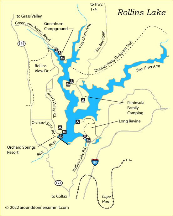
Rollins Lake
Location: 3 miles north of Colfax, off Highway 174
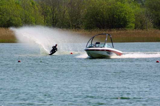
Types of Boating: all types, including jet skis and waterskiing.
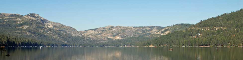
Rollins Lake has 840 surface acres and 25 miles of shoreline. It is along the Bear River at an elevation
of 2,170 feet. The lake has four marinas with launch ramps which are part of privately operated campgrounds and
resorts open to the public, including for day use.
Long Ravine
Long Ravine Resort has a marina, launch ramp, gas, boat slips, boat rentals, store, swimming, and camping.
Long Ravine at Rollins Lake
Long Ravine Day Use Fees:
- $15 per vehicle with 4 people
- $20 per vehicle with a watercraft
- $5 for each additional watercraft.
- Season passes available.
Peninsula Family Camping
Located on a peninsula on the northeast side of the lake. Access via You Bet Road off Highway 174, 7 miles
north of Colfax. Includes campground, cabins, restrooms, launch ramp, boat storage, gas, and boat rentals.
Peninsula Campground
| Boat | Seats |
|---|---|
| Check Sierra Pontoon Rentals for details and prices | |
| Pontoon Boats 18' - 24' | 8 - 14 |
| Canoe | 3 |
| Kayak | 1-2 |
| Stand-up Paddleboard | 1-2 |
Orchard Springs Resort
Orchard Springs Resort is located on the west shore of Rollins Lake, off Highway 174 via Orchard Springs Road.
They are open year-round. The resort has campsites, cabins, a beach, a marina, and store.
Orchard Springs Resort
Orchard Springs Day Use Fees:
- $15 per vehicle with 4 people
- $20 per vehicle with a motorized boat
- $18 per vehicle with a non-motorized boat
- $5 for each additional watercraft.
- Season passes available.
Greenhorn Campground
Greenhorn Campground is located on the northwest side of the lake. To reach the campground take
Greenhorn Access Road off Highway 174 and follow the road to the campground. They have a marina, launch
ramp, boat rentals, store, arcade, campgrounds, and beach.
15000 Greenhorn Access Road
(530) 272-6100
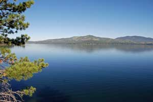
Donner Lake
Location: Next to Interstate 80 near Truckee
Types of Boating: All kinds - waterskiing, wake boarding, jet skiing, rowing, sailing, canoes, kayaks
Donner Lake has 960 surface acres and rests at an elevation of 5,900 feet. The lake has a 35 MPH speed limit. Windsurfers enjoy the lake along with boaters in canoes and kayaks.
Along the north shore are over 30 public docks for boaters and swimmers.
Public Launch Ramp: Northwest end of lake
Donner Lake Watersports and Marina
Donner Lake Marina
15695 Donner Pass Rd., Truckee CA
(530) 582-5112 Donner Lake Marina
Located at the west end of the lake just west of the launch ramp.
Marina with docks, slips, boat rentals, fuel available nearby
Donner Lake Watersports
East shore at Donner Memorial State Park.
(530) 582-5112 Donner Lake Marina
| Boat | Length | Seats |
|---|---|---|
| Fuel is included. Prices subject to change. Skis, Tubes, Boards, Wet Suits available. | ||
| Personal Watercraft - Sea Doo GTX | ~10' | 3 |
| Centurion FX44 | 25' | 12 |
| Centurion Enzo Wakeboat | 23' | 12 |
| Ski Boat | 21' | 10 |
| Regal Ski Boat | 20' | 8 |
| Fishing Boat | 14' | |
| Super Pontoon Boat | 28' | 20 |
| Pontoon Boat "Big Blue" | 26' | 15 |
| Pontoon Boat "Cute Toon" | 21' | 10 |
| Scout Fiberglass Fishing Boat | 16' | 5 |
| Aluminum Fishing Boat | 14' | 4 |
| Hydrobikes | 1 | |
| Pedal Boats | 2 | |
| Kayaks | 1-2 | |
| Canoes | 4-5 | |
| Stand-up Paddleboards | 12' | |
Sterling Lake
Location: 5 miles north of Cisco Grove on Rattlesnake Road
Types of Boating: Fishing boats, kayaks, canoes
The road to Sterling Lake is steep and winding in
places. Sterling Lake has a 10 MPH speed limit. There is no launch ramp.
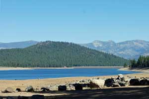
Lake Spaulding
Location: 25 miles east of Nevada City, off Highway 20
Types of Boating: all types, including jet skis and waterskiing, popular for kayaks
698-acre Lake Spaulding is at an elevation of 5,000 feet with 9 miles of shoreline. The spectacular lake set among high granite cliffs can be seen by motorists passing on nearby Interstate 80. Visitors enjoy camping, fishing, hiking, swimming, picnicking, and boating. It has a 35 MPH speed limit during the day and 10 MPH at night.
Launch Ramp west end of lake near the dam, $7 for day-use parking only, $10 launch and park fee, $50 annual pass, usually open May 18 to October 15
Lakes Along Bowman Lake Road
Fuller Lake
Location: 3.5 miles north of Highway 20 on Bowman Lake Road.
Types of Boating: Fishing boats, kayaks, canoes, rafts. This half-mile long lake has a 10 MPH speed limit, making it popular with anglers who like to use float tubes to work the best parts of the lake. Access is free at the parking area near the dam. The day use area and launch ramp farther up the shore both charge a fee (see below).
Boat Launch and Day use Fees: Day use $7 at launch area, $10 for launch & day use
Rucker Lake
Location: 5 miles north of Highway 20 on Bowman Lake Road, turn at dirt road to the lake
Types of Boating: Non-motorized boats only, hand launched.
Carr Lake
Location: 8.5 miles north of Highway 20 on Bowman Lake Road, turn onto dirt road and go 3 miles to lake. High clearance vehicles needed.
Types of Boating: Fishing boats, kayaks, canoes. 10 MPH speed limit. Hand launched boats.
Feeley Lake
Location: 8.5 miles north of Highway 20 on Bowman Lake Road, turn onto dirt road for Carr Lake and go 3 miles to lake. High clearance vehicles needed. Hike one mile to Feeley Lake.
Types of Boating: Light fishing boats, kayaks, canoes
Ambitious boaters could carry a lightweight craft the one-third mile to Feeley Lake along a fairly manageable dirt road. 10 MPH speed limit. Hand launched boats.
Lower Lindsey Lake
Location: 8.5 miles north of Highway 20 on Bowman Lake Road, turn onto Carr-Lindsey Lakes dirt road. After 2 miles turn left onto Lindsey Lake Road. Continue 2 miles to lake. High clearance vehicles needed.
Types of Boating: Fishing boats, kayaks, canoes. 10 MPH speed limit. Informal launch area for boats.
Lake Valley Reservoir
Location: 2.5 miles south of Interstate 80 at Yuba Gap
Types of Boating: Fishing boats, kayaks, sailboats, canoes, wind surfing. Water skiing is not allowed.
1.9-mile-long Lake Valley Reservoir is not as well-known as some of the other lakes in the area. Fishermen like to get out early in their boats to fish before winds pick up. Kayakers enjoy exploring the shoreline. In late summer the water level is drawn down as it is needed. There is a campground near the dam.
Silvertip Day Use and Launch Ramp: Located on the north side of the lake. $10 launch and park fee. $5 for day-use only. Usually open from mid-May through mid-November.
Lakes North of Truckee
Stampede Reservoir
Location: 15 miles northeast of Truckee. At an elevation of 6,000 feet,
Types of Boating: Open to all kinds of boating, including waterskiing, jet-skiing, and sailing
The only facilities at the lake are two campgrounds and boat launch ramps.
Launch Ramps
- Logger Campground - concrete ramp
- Emigrant Group Campground - 3 lanes
- Captain Robert's Boat Ramp - 3 lanes, concrete, $4 for day-use
Stampede Reservoir Boating Regulations
- Quagga and zebra mussel boat inspections recommended before launching.
- 45 MPH Speed Limit from sunrise to sunset and 10 MPH from sunset to sunrise.
- 5 MPH speed Limit within 200 feet of swimming beach, swimmers, moored boats, and launch ramp
Boca Reservoir
Location: 1 mile north of Interstate 80, 7 miles east of Truckee
Types of Boating: Waterskiing, jet skis, fishing, sailing, kayaks, canoes
With 980 surface acres, Boca Reservoir is a favorite destination for water sports enthusiasts. During summer afternoons the lake is often alive with waterskiers, wakeboarders, and jet-skiers. Anglers try to get out early before the churn of big powerboats takes over.
A paved boat ramp is located on the southwest side of the lake, close to Boca Campground. During times of low water, the ramp is not useable.
Prosser Creek Reservoir
Location: 3 miles west of Boca Reservoir and 5 miles north of Truckee
Types of Boating: Fishing, canoes, kayaks (5 MPH speed limit)
Prosser Creek Reservoir is
a quiet contrast to Boca. Prosser's 5 MPH speed limit makes Prosser a great place for fishing, kayaking, and canoeing. The lake spreads over 750 surface acres with multiple arms and 11 miles of shoreline.
Several launch ramps are located around the lake, several at the end of a peninsula near the campgrounds on the west side and another on the north shore. Campgrounds are located around the lake and a picnic area is found next to Prosser Ranch Group Campground.
Independence Lake
Location: 20 miles north of Truckee via Highway 89 and Independence Lake Road
Types of Boating: Only boats provided by the Nature Preserve at Independence Lake. This is an effort to keep invasive species out of the lake. Float tubes are not allowed.
The Sierra Pacific Power Company sold the land around Independence Lake to the Nature Conservancy in 2010. Now the Truckee Donner Land Trust and The Nature Conservancy jointly manage the property.
Watercraft are available for use on Independence Lake Preserve from June through October. In 2012 a limited number of boats were provided free on a first-come, first served basis. Boats include 14-foot aluminum boats with 9.9 HP outboards, kayaks, and pontoon float tubes.
For more information about visiting the lake, see Nature Conservancy.
Webber Lake
Photo courtesy John Peltier
Location: 17 miles north of Truckee on Highway 89 and then 8 miles west on Jackson Meadows Road. Watch for sign for TDLT Lacey Meadows parking area.
Types of Boating: All types of boats are permitted on Webber Lake, but there is a 5 MPH speed limit. Kayaking, canoeing, and paddle-boarding are particularly popular at the lake.
Webber Lake was acquired by the Truckee Donner Land Trust in 2012. The lake and surrounding meadows are open to the public for boating, fishing, swimming, hiking, and camping. A boat ramp is available. Before launching, owners of all watercraft must complete an Aquatic Invasive Species Self-Inspection Launch Certification Permit.
Find more information about Webber Lake at Truckee Donner Land Trust - Webber Lake and Lacey Meadows
Other Donner Summit Area Lakes
Fordyce Lake
Fordyce Lake is only accessible by 4-wheel vehicle over rugged OHV roads. Most 4-wheelers approach via Eagle Lakes or Meadow Lake. Only non-motorized boats are allowed on the lake. Canoeists and kayakers enjoy exploring its nearly 4-mile length.
French Meadows Reservoir
3-mile long French Meadows Reservoir is 36 miles east of Foresthill, which is 17 miles from Interstate 80 at Auburn. All kinds of boating are permitted at the lake, but submerged hazards make it risky for waterskiers and high-speed boating. There are two paved launch ramps and several campgrounds.
Jackson Meadows Reservoir
Jackson Meadows Reservoir is 32 miles northwest of Truckee via Highway 89 and Jackson Lake Road. All kinds of boating are permitted on the lake. There are two launch ramps, one on the east side at Pass Creek Campground and the other on the west side at Woodcamp. The 3-mile-long reservoir is an elevation of 6,000 feet. It has one boat-in campground.
Meadow Lake
Meadow Lake is located 35 miles from Truckee via Highway 89, Jackson Lake Road, and Meadow Lake Road. The last several miles require high clearance vehicles. Trailers are not advised. Boating is limited to hand-launched boats.