The Western States Trail
The Western States Trail extends from Salt Lake City, Utah, across the Great Basin and over the Sierra Nevada to Sacramento, California. Originally a Native American route, the California portion of the trail was later taken up by trans-Sierra travelers in the 19th century seeking a passage to the Nevada mines. William Brewer, a member of Whitney's survey party, crossed the Sierra by the trail in 1863. He remembered, "It was grand, but a very rough trail, in fact, 'awful bad,' and, what was worse, no water."
Today the trail is also used by day hikers, backpackers, horseback riders, runners and other outdoor enthusiasts. The lower portions west of Foresthill are best enjoyed in the spring or late fall when temperatures are mild.
The Western States Trail gained notoriety in modern times when Wendell T. Robie and several other horsemen rode the 100 miles from Squaw Valley to Auburn in a single day. Soon afterward Robie organized the Western States Trail Foundation, followed by the Western States Trail Ride, which today is known as the annual Tevis Cup.
In 1974 Gordy Ainsleigh decided to participate on foot along with the Tevis Cup riders. He succeeded in completing the course in less than 24 hours, giving birth to the idea of a 100-mile foot race along the trail. The first Western States Endurance Run was held in 1977 with 14 runners. By 1979 the foot race had expanded to 143 runners. Today a maximum of 369 runners are selected through a lottery system.
Western States Trail Route across the Sierra
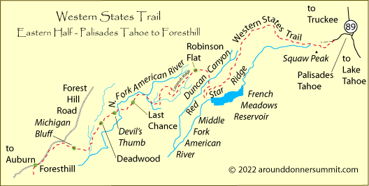
Palisades Tahoe to Robinson Flat, 30 miles
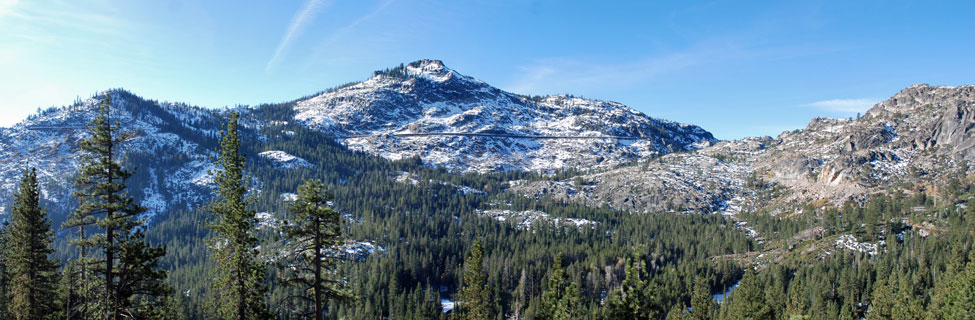
The trans-Sierra portion of the Western States Trail begins at 6,230 feet at Palisades Tahoe (formerly Squaw Valley) and climbs the steep eastern face of Squaw Peak, crossing the crest of the Sierra near the Watson Monument Emigrant Pass Marker at 8,760 feet. There the trail passes briefly through the Granite Chief Wilderness and descends to the Forest Hill Divide. The trail follows the ridge of the divide for 8 miles before turning south toward French Meadows Reservoir and looping back north to Robinson Flat.
Robinson Flat to Foresthill, 32 miles
After a short climb out of Robinson Flat to the flank of Duncan Peak the trail begins a long descent to a crossing of the Middle Fork of the American River, dropping more than 4,000 feet in 16 miles. Several more ridge crossings around Michigan Bluff challenge hikers, runners, and riders alike. Then the trail follows the Foresthill Road into Foresthill.
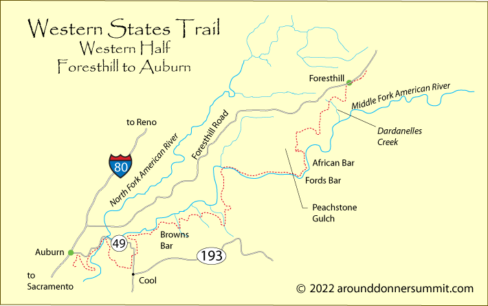
Foresthill to Auburn, 38 miles
From Foresthill the trail winds south and begins a 2,000-foot descent into the canyon of the Middle Fork of the American River again. After 5 miles along the north side of the river the route crosses to the south side and winds along the rim of the canyon. About 25 miles from Foresthill the trail turns back into the American River Canyon for a third time, climbs out again near the town of Cool, and then returns for a fourth time at the confluence of the middle and north forks. A bridge crossing leads to an arduous climb to the town of Auburn.
Beyond Auburn
Although many competitions use Auburn as their ending point, the Western States Trail passes under Pacific and then connects with the paved road above the former dam abutment. From there it leads to Maidu Drive and then to the Rattlesnake Bar Trail to Folsom Lake. Beyond Folsom Lake the trail connects with American River Parkway into Sacramento.
Tevis Cup
The Tevis Cup is a one-day, 100-mile horseback trail ride from Robie Park (near Palisades Tahoe) to Auburn. The ride has been held every year since 1955. Riders who complete the course within the 24-hour limit and whose horse is considered to be "fit to continue" earn a silver Completion Award Buckle. The Tevis Cup is awarded to the rider who completes the course in the shortest amount of time and whose horse is in good condition.
Great care is taken throughout the trail ride to check the condition of the horses to be sure they are fit to continue with the ride. Veterinary inspections are held before the ride, at check points along the course, and at the finish in Auburn.
The Tevis Cup Course
The ride begins at Robie Equestrian Park, east of Highway 89. Riders follow the trail 9 miles down to the Truckee River and then into Squaw Valley. From there, for the most part, the riders follow the Western States Trail. To adjust for the miles ridden from Robie Park to Squaw Valley and still keep the course to 100 miles, riders bypass the Red Star Ridge and Duncan Canyon sections of the Western States Trail and follow Forest Hill Divide Road into Robinson Flat instead. The ride finishes at the Auburn Fairgrounds.
Where to Watch the Ride
The ride is usually held near the end of July or in early August every year. The next ride will begin on July 20, 2024. For those who want to watch the
ride, Foresthill is a good location. The leading riders usually begin to show up there in the middle of the afternoon on Saturday. Another good spot is the finish line at the Auburn Fairgrounds.
The Tevis Cup
100 Mile Endurance Run - Palisades Tahoe to Auburn
The annual 100-mile endurance run from Palisades Tahoe (formerly Squaw Valley) to Auburn, California, is one of the premier races in the West. Applicants must complete a qualifying run and then enter a lottery to see if their number is drawn to allow them to be one of the participants. Only one in ten is selected.
Race Overview
The race is held on the last full weekend in June. This year it will be held on
June 29-30, 2024. Runners begin at 5:00 AM by ascending more than 2,500 feet in 4½ miles from Squaw Valley to Emigrant Pass. Beyond the summit, the trail passes into rugged back country terrain, climbing an additional 15,000 feet and descending more than 22,900 feet. Racers pass through 24 check points before reaching the finish line at Placer High School in Auburn. Runners must reach the finish line within 30 hours to qualify for awards.
Western States Run